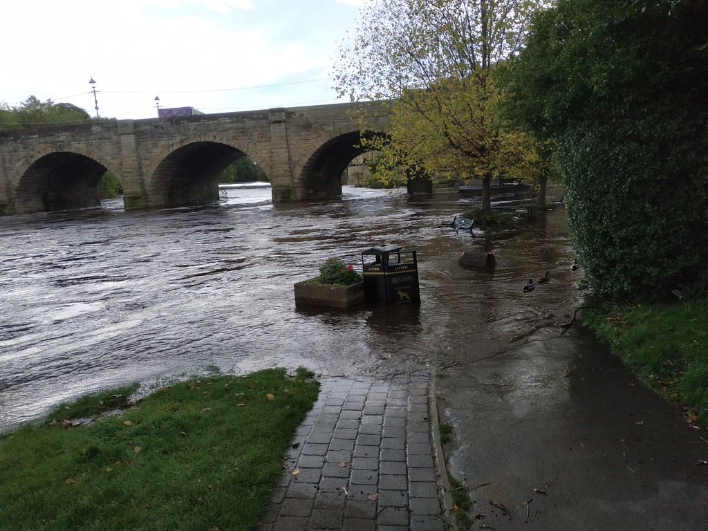
Pictured: Flooding incident at Barnsdale Road
Around 6,600 homes in the Wakefield district are permanently at risk of flooding from sudden storms.
It’s actually surface water flooding that poses a bigger threat to the area than rising river levels as parts of the district’s drainage system could easily be overwhelmed by heavy rain.
This is why Paul Maddison, flood risk manager for Wakefield Council, is leading the LoRaWAN project to set up a network of digital sensors across the region as a solution to this growing concern. The aim of the project is to give people earlier warnings about the risk of surface water flooding in West Yorkshire following a successful bid for £97,000 by West Yorkshire Flood Innovation Programme from the Discovery Phase of round six of the Local Digital Fund to test whether using smart technology for such a system would be viable.
Working with Kirklees and Leeds council, Paul is now leading the project into the next stage which is to pilot LoRaWAN before expanding it to the region.
This is in line with a recommendation in the Global Status of Multi-Hazard Early Warning Systems 2023 report which is to start small and focus on priority hazards identified locally then develop, text and expand over time so that foundations such as governance can be set and technical capacity and partnerships can develop. The report also emphasises the importance of sharing good quality data for monitoring and used in decision making.
“A major issue for us is that there are no systems in place for early warnings of surface water flooding. It’s difficult to predict compared to flooding of rivers, which is well-monitored with warnings in place.” Paul Maddison, flood risk manager for Wakefield Council
“Heavy rainfall is becoming much more frequent due to climate change. During recent storms, the amount of water that goes down the gullies, into the sewerage system is much bigger than what they are designed to cope with.
“The condition of a lot of the underground pipe work is not known and where it may not be in very good condition if it collapses then people will be flooded.”
A network of surface water sensors would provide an early warning system enabling flood managers to respond better during incidents. They would get data quickly about specific locations so that they could be more proactive and target areas at risk. This information could also be shared through user-friendly platforms with members of the public, flood wardens and community flood action groups.
LoRaWAN is a cost effective system to introduce and already being used by local authorities in the UK to help mitigate flooding. Once the gateway and dashboard have been established, the system can be scaled up and has multiple uses including monitoring air quality, traffic and footfall during the COVID pandemic.
“It would be an absolute dream to have real time intelligence on the ground from sensors in different locations during a flood event,” said Mick Devine, emergency planner at Wakefield Council.
“We currently don’t have any real evidence-based, scientific knowledge to back up some of the decisions we make around surface water flooding, we have to rely on having enough resource to send people out on the ground.
“If we were challenged on a decision we made about why we had evacuated an area at a certain time due to a risk of flooding, for example, we could use accurate information provided by LoRaWAN to justify it and make better use of the resources we have available during an incident.”
Much of the groundwork has already been done in Wakfield for LoRaWAN to be most effective. Officers have mapped out hotspots for flooding across the district so they know locally where the highest impact from flooding is likely to be locally and where the vulnerable people most likely to be at risk live and work.
Amy Boyd, emergency planner at Wakefield Council added “We could use LoRAWAN for so many other things as well as providing an early warning system for flooding. Once we had the infrastructure in place, it could be linked to other systems and provide a wealth of information relating to different areas. It could help us to take an evidence based approach for monitoring people, assets and buildings. Our customer service managers would find it useful to see reports from sensors and match it to their own data.
Integration with other systems such as Resilience Direct – an online private ‘network’ which enables civil protection practitioners to work together across geographical and organisational boundaries preparing for and during emergency incidents – should be relatively straightforward.
Local flood authorities and the Environment Agency have really good avenues for getting information out to residents prior to, during and after incidents said Amy. One of these is through flood wardens who become crucial during incidents as eyes and ears on the ground and Wakefield is currently having a drive to recruit more of them.
The information provided by the LoRaWAN sensors would be more accurate and in real time helping them to reduce the impact of floods and keep communities safe.
In 2015, the Boxing Day Floods had catastrophic consequences for West Yorkshire resulting in 4,000 homes and 2,000 businesses being flooded at a cost of £100 million. However people have short memories and think it won’t happen to them, said Amy.
There are still motorists who drive into flood water, get stranded and then expect the fire services to become a pick up service for their vehicles, she said.
Insurance companies won’t pay out for damage to cars when drivers deliberately do that. There are even cases of people putting their lives in danger using paddle boards and jet skis to get through flood water.
One main route from Castleford to Allerton Bywater in Leeds District, is Barnsdale Road, which is a flooding hotspot, and would really benefit from LoRaWAN. During an incident, closing one end of the road comes under the control of Leeds Council’s emergency planners and closing the other end comes under control of Wakefield Council. One of the local authorities could close their half of the road without the other needing to which then causes problems.
“If there were sensors monitoring the surface water along the route, it would be much easier to coordinate this,” said Mick. “There are also instances when a road dips under a bridge when it is difficult to gauge the level of the surface water when having information from a sensor would help.”
Pictured below: Flooding in Wetherby