
The aim of this project is to improve the response to surface water flooding events by exploring the use of a LoRaWAN network (Long Range Wide Area Network) to provide a flood warning system which uses more accurate, real-time information.
Plans are underway to create a network of sensors across West Yorkshire to give people earlier warnings about the risk of surface water flooding following a successful bid for £97,000.
The funding has come from the Discovery Phase of round six of the Local Digital Fund to test whether using smart technology for such a system would be viable.
This project will be led by Wakefield Council, who are working with Kirklees and Leeds Council to scope the project, carry out further assessment of the Long Range Wide Area Network (LoRaWAN) and pilot the sensors.
Current flood responses are reactive rather than proactive and there is no early warning system in place. The network of sensors would transmit real-time surface water levels to a central hub and create an early warning system of potential flooding.
The project will focus on surface water level monitoring using new bollard sensors and rainfall, soil moisture and gully sensors. The networks are low energy and low-frequency allowing the transfer of data from remote, battery-powered sensors to user-friendly dashboards. It will enable information related to flooding to be shared across boundaries, between local authorities and partners.
The first stage of the project has been to map catchment areas to identify flood risk sites and propose LoRaWAN gateways and sensor locations for an early warning system for floods.
As part of the project, iCASP has run a series of workshops to help partners share technical expertise and practical experiences of dealing with flooding.
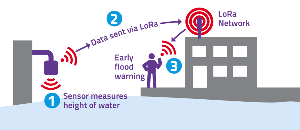
LoRaWAN Flood Sensor Pilot Project Diagram, Cambridge
The plan is to roll the sensors out across the region to improve its resilience to flooding and then to introduce them further afield.
The aim of the Local Digital Fund is to make local government services safer, resilient, and cost-effective. These projects aim to help create the next generation of local public services, where technology is an enabler rather than a barrier to service improvements, and services are user-centred.
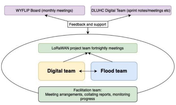
LoRaWAN Project Roadmap
A roadmap has been created for this project which outlines the governance and key questions for the project team to collect information on.
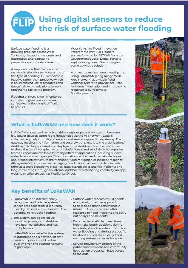
LoRaWAN Information Leaflet
An informative flyer has been produced which outlines how using digital sensors can reduce surface water flooding. The leaflet explains how LoRaWAN works, its benefits and current application.
LoRaWAN narrated presentation
You can watch a presentation with a voiceover to find out how the region could benefit from LoRaWAN.
User Research Report
A user research report has been created to summarise the project aims, flood risk stakeholder interview findings, the residents and responders workshop findings and next steps.
Business Case
A business case report has been created after the completion of a discovery ‘scoping’ phase. Presented here is a business case for Alpha-stage funding to develop a pilot scheme testing a Long-Range Wide Area Network for surface water monitoring, infrastructure maintenance and improved flood response.
End of project reports
Creating a digital smart flood warning system for surface water flooding in West Yorkshire: System Integration and Data Pipeline report
Laboratory Report May 2026
West Yorkshire: Flood and Coast Conference paper 9-11 June 2026
LoRaWAN Sensor Mount Options: Concept Note June 2026