Overview
In light of the upcoming COP26 hosted by the city of Glasgow this November, the Met Office held a virtual hackathon to explore opportunities for boosting societal resilience to climate change. The two-day event on the 16th and 17th of March was aimed at finding new ways to use data to deal with challenges and exploit the opportunities of our changing climate. Over 170 people joined the event and 21 teams worked on three key themes:
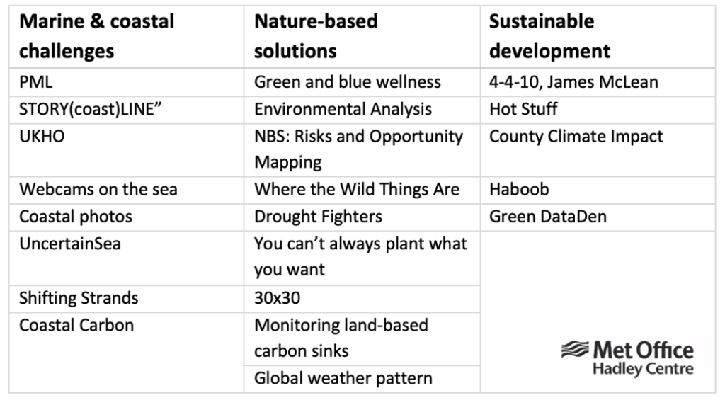
Phoebe (team 1) and Hebin (team 2) from iCASP attended the event, joining two teams focused on challenges around nature-based solutions (NBS). NBS, which work with and enhance nature to tackle societal challenges are increasingly advocated for climate change mitigation and adaptation.
Team 1: NBS – Risk & Opportunity Mapping
Aware of the multi-benefits of NBS, the team explored areas at risk to climate change across greater Manchester using available datasets to assess the opportunities for implementing NBS. The team used Mapping GM, the home of Greater Manchester mapped data, to identify open access datasets regarding air quality, flooding and socio-economic data to help outline areas that are vulnerable to climate change within greater Manchester. This hackathon challenge has relevance to the iCASP project, Environmental science to promote public health and well-being, which aims to integrate environmental data into the Strategic Health Asset Planning and Evaluation (SHAPE) GIS tool to promote climate-resilient decision-making.
Once the raw data was extracted, it was fed into a geographic information software (GIS) and aggregated to produce a climate vulnerability ‘hotspot’ map. Using GIS to visualize the data allowed the team to analyze areas of high vulnerability by assessing where multiple risks intersect. For example, people living in areas of high flood risk, poor air quality and high levels of deprivation are likely to be particularly vulnerable to climate change and therefore, areas for NBS opportunities can be prioritized (see figure 1).
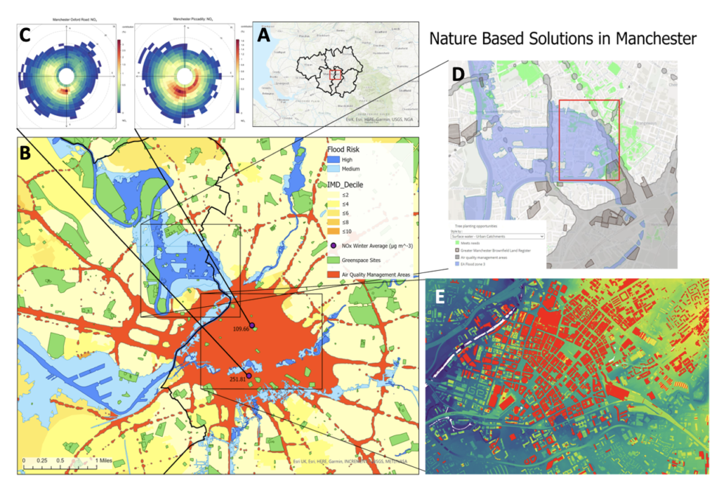
Figure created from datasets available at Mapping GM – https://mappinggm.org.uk/
Figure 1 displays combined outputs generated over the course of the hackathon. It demonstrates that despite central Manchester being vulnerable to multiple socio-environmental risks, it is also an area for NBS opportunities. Data available from the IGNITION project funded by EU Urban Innovation Actions provides a dataset for different NBS interventions, including green-walls, green-roofs, green space and sustainable drainage systems. The IGNITION database acts as a central evidence repository of existing and emerging NBS evidence, covering their suitability for reducing environmental issues, including flooding and poor air quality.For example, using information from 1C which identifies the source of high NO(2) levels, combined with the IGNITION database for understanding suitable NBS to reduce these issues could help city planners implement measures such as green-walls which face the direction of high pollutant sources.
This information would contribute to decision-making processes for strategies including the Great Outdoors – A Green & Blue Infrastructure Strategy for Manchester (2015 – 2025) and the Manchester Climate Change Framework Strategy (2020 – 2025).
Team 2: NBS – 30 By 30 Policy Initiative
In the global climate negotiations, many countries are pledging to meet the 30 by 30 policy goal of protecting 30% of terrestrial and 30% of marine territory by 2030, including the UK. The UK Prime Minister, in September 2020, has committed to protecting 30% of the UK’s land by 2030, along with the Devolved Administrations. Our team was comprised of 7 members working in the governments, universities and consulting companies located in Scotland, Leeds, London, Bristol and Wales. We asked the key question:
What should be the level of protection and management for both biodiversity and climate change mitigation and adaptation?
We took a holistic approach to consider the full range of marine and terrestrial protected areas across the UK by visiting publicly available guidelines and datasets. We noticed that the UK already is close to this target in both the terrestrial and marine (Figure 2) having a diverse range of designations. However, designation does not necessarily mean protection; effective conservation management and adaptation require long-term management considering climate change impacts (Figure 3).
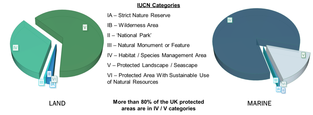
Figure developed by the team based on datasets from https://www.protectedplanet.net/country/GBR
Figure developed by the team based on datasets from https://www.ceda.ac.uk/
How well protected are these areas? We noticed that the International Union for the Conservation of Nature (IUCN) classification system with 6 levels of protection range from total protection to landscape and seascape designations but do not map directly to UK designations (Figure 4).
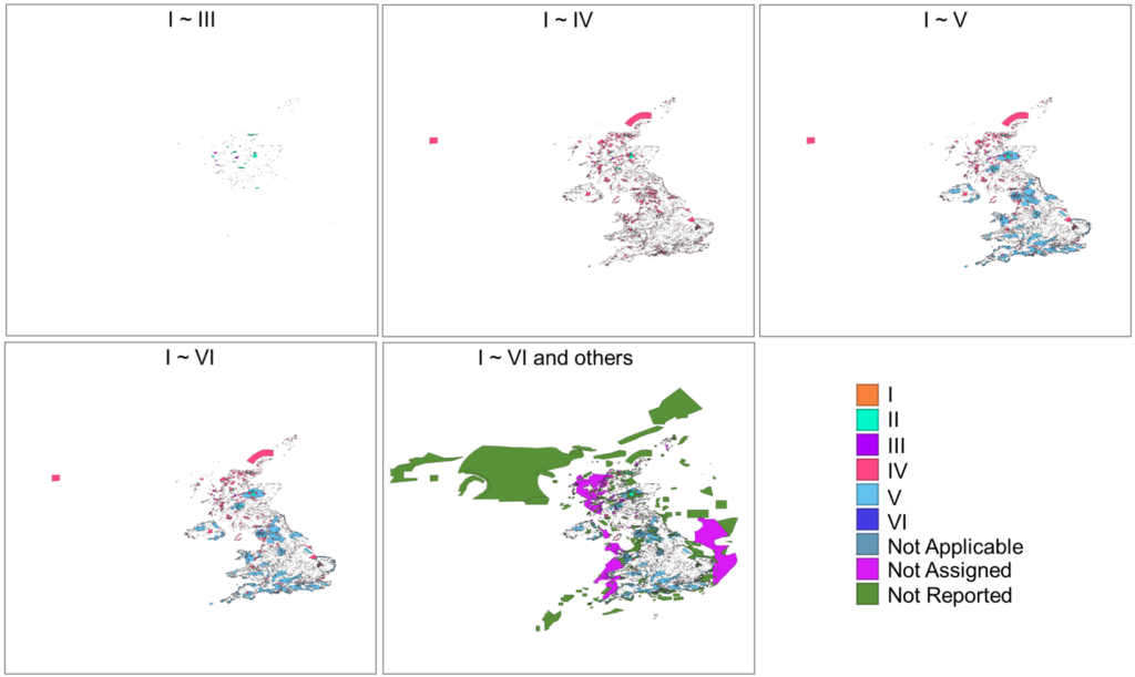
Figure developed by the team based on datasets from https://www.protectedplanet.net/country/GBR
We recognized that designation of protected areas needs to be an on-going process of active management with clear biodiversity and climate change goals, along with proactive local community engagement. It is important that the 30 by 30 initiative is implemented to deliver nature-based solutions that benefit humans and biodiversity rather than just climate mitigation that can potentially have negative side effects if poorly implemented. Our messages are:
Delivery of 30 by 30 needs to have long-term perspective which takes into account species and ecosystem needs under future climate scenarios; right designation or protection in the right place!
Our Experience and Future Hackathon Events
Hebin commented that “it was so amazing to work with a team of professionals from various backgrounds with a shared and sincere concern for protecting the natural environment; everyone went above and beyond within the short timeframe, developed a true team spirit in building consensus around vaguely defined concepts, and together produced a joint output that contributes to the climate policy debate”. Phoebe also enjoyed herself stating, “It was the first hackathon that I’ve attended but it certainly won’t be the last! The opportunity to meet people with a wide range of skillsets was really interesting and rewarding. I am proud of the outputs our team generated over the course of the hackathon and hope our work inspires NBS opportunity mapping beyond Greater Manchester.”
Check out future hackathon events – You won’t regret it!