
The use of natural flood management (NFM) has been championed in recent years due to its multiple benefits and resilience to climate change. NFM incorporates such interventions as leaky dams, tree planting, and offline storage ponds, but can also include different soil management techniques such as changes in tillage practices to reduce compaction. There is an increasing need to quantify the impacts of NFM including flood risk and their multiple benefits in order to establish, for example, payment bands in ‘Payment for Outcomes’ schemes.
This project aims to quantify the flood risk benefits for different intervention scenarios in the Upper Rother Catchment, South Yorkshire & North East Derbyshire. It will provide an evidence directory for the Upper Rother, which will enable on the ground interventions to be placed with a quantified impact on flood risk.
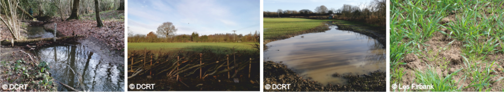
Figure showing common NFM interventions: leaky dam, hedge laying, offline pond and soil management. Thanks to the Don Catchment Rivers Trust and Les Firbank for the images.
Our new Upper Rother Catchment iCASP project team consists of Dr Janet Richardson and Dr Thomas Willis, iCASP impact translation fellows; Dr Debbie Coldwell and Dr Edward Shaw, Don Catchment Rivers Trust (DCRT); lead academic Dr Megan Klaar, University of Leeds and Prof. Colin Brown, University of York.
Dr Debbie Coldwell, NFM officer for the Don Catchment Rivers Trust, said: “We are very excited to be able to continue our work with iCASP which will allow us to take a more strategic approach to our NFM work, targeting areas that will have the greatest impact on reducing flood risk in and around Chesterfield. Having a better understanding of the scale of the works required to have a meaningful impact on reducing flood risk and what we need to do to achieve that will be incredibly valuable to the project and is not something we would have had the resources to do on our own”.
The project aims to quantify the flood risk benefits (in terms of flood peak and time to peak) for different intervention types in the Upper Rother and River Hipper sub-catchments. In order to do this, SD-TOPMODEL will be used which is a hydrological model capable of modelling flow through a catchment and can be modified to represent different interventions. The biggest advantage of using SD-TOPMODEL for the modelling is the ability to integrate soil management techniques, as the flow of water within the model can interpret different types of flow including overland and sub-surface.
Soil management is a vital aspect of NFM and offers many benefits, including flood management, as well as more efficient crop growth, water quality improvements and carbon storage. It is also likely to benefit the landowner’s business and therefore may have a higher uptake. Working with key partners in the region (including the Don Catchment Rivers Trust NFM steering board – Environment Agency, Derbyshire County Council, North East Derbyshire District Council, Chesterfield Borough Council); different scenarios will be prioritised and tested, for example, tree planting and soil management (including soil drainage improvement through introduction of organic material, reduced grazing stock in fields, reducing compaction from vehicles and reducing access for livestock to the riparian zone). This will allow the different intervention impacts to be quantified, which will allow for prioritisation of interventions whilst developing a strategic vision for the catchment (for example, how many interventions are needed to produce a 5% reduction in flood risk? Where are the interventions best placed for the biggest impacts?). The applicability of SD-TOPMODEL to these problems has been investigated in another iCASP project that investigated the impact of land use management on flooding in the Upper Calder valley.
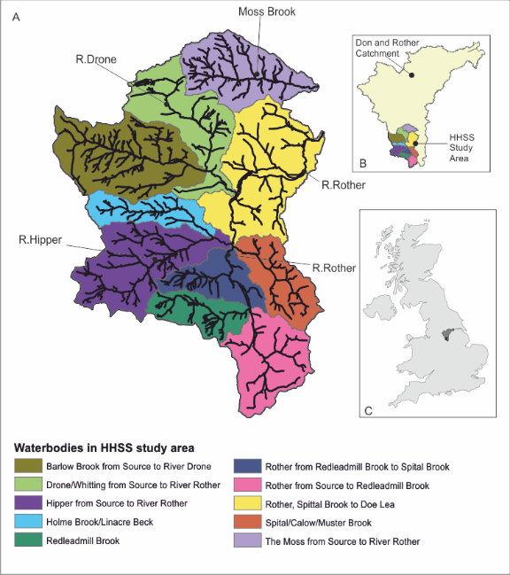
Figure showing the study location of the project – the River Hipper and Upper Rother catchments.
This project is a follow on project to the Hidden Heritage Secret Streams iCASP project, which was based in the Upper Rother Catchment, and brought together open access data to map the best sites for interventions by creating hotspot (risk) and opportunity maps. In that project, interventions were chosen which would help slow the flow, decrease diffuse pollution and increase landscape connectivity. Mapping in the initial project primarily used GIS and the rainfall-runoff models SCIMAP. The full method can be downloaded here. The initial project highlighted areas of the catchment where opportunities could be placed to help reduce risk, for example, flood risk, however, the benefits were not quantified. The Environment Agency’s flood storage calculator was used to assess what sub-catchments would have the biggest impacts on downstream flood risk. Delaying flood peaks in the Upper Rother and the River Hipper, were shown to have a 10% and 8% reduction in flood risk respectively, significantly reducing flooding in Chesterfield. This information from the Don project highlights the main sub-catchments to focus NFM works on to have the biggest impacts on flood risk.
We will be kicking off our new Upper Rother Catchment project in April 2021. Please let us know if you would like to be kept up to date with this project as it develops by emailing the iCASP team at [email protected].